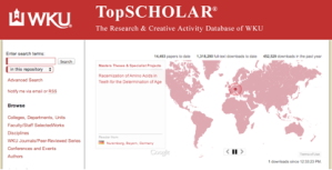
Western Kentucky University’s research and creative database (TopSCHOLAR) has added a new feature called Readership Map. The new map pinpoints where researchers are located from around the world and what specific data they are viewing at that moment.
“This truly shows the international reach of the intellectual capital of WKU,” said Dean Connie Foster of WKU Libraries. “If you go to the website at any time, faculty, staff, and students’ materials are being downloaded all over the world. It’s a visual method to see where our scholarly works are reaching.”
According to Bepress, the parent company for the repository software Digital Commons, the following describes how the Readership Map works:
The Digital Commons Readership Map provides a dynamic visual display of location-based article downloads of open-access materials from Digital Commons and SelectedWorks sites. When a visitor downloads an article, a highlighted pin drops on the map to indicate the approximate location of the download. The title of the article and the title of the article’s publication (e.g., Dissertations) appears in a feed to the left of the map. When another download occurs, another pin drops; the highlight moves to the second pin, and the feed updates with new title information.
Go to www.digitalcommons.wku.edu to see the Readership Map in action.
